|
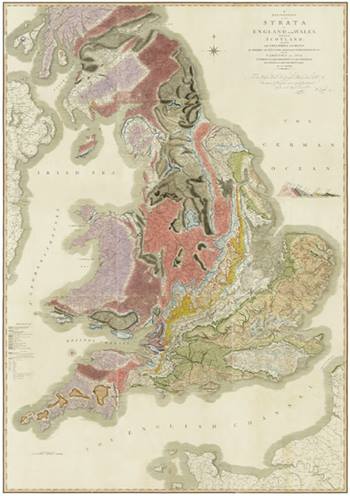
| One of four copies of William Smith's 'A delineation of the Strata of England and Wales, with part of Scotland...' which the Society holds. |
This famous map is considered to be the first geological map of a complete country ever made and was the culmination of over fifteen years’ work by its author, the English mineral and canal surveyor William Smith (1769-1839). The mapping is based around Smith’s discoveries that fossils could be used as indicators to identify specific rock strata, and that these strata appeared in a regular and predictable sequence across the country.

|
| William Smith |
The base map was engraved on fifteen separate copper plates and is a redrawn, simplified version of the publisher John Cary’s earlier 'New Map of England and Wales, with Part of Scotland' (1794) as Smith was anxious to remove topographical clutter that might otherwise obscure the geological lines.
Each map was hand-coloured by one of Cary’s colourists, the colours chosen by Smith to match the natural hue of the strata each represents (ie coal is marked as grey and black), with the exception of the Chalk which is shown in green. A denser tone was used towards the base of each stratum to give an immediate visual indication of dip and superposition. Smith’s map was the first to show the strata of the whole of England and Wales in such a way that the sequence of the strata was readily apparent. This is most clearly seen in the Mesozoic strata of southern and eastern England, the beds with which Smith was perhaps the most familiar.
Although all copies of the map are dated 1 August 1815, Smith’s great map was first published in mid-September 1815 when a small number of copies were distributed to subscribers including the Geological Society and its first president George Bellas Greenough. The main issue of the map, with each copy numbered and only signed by Smith if he approved of the quality of the colouring, began on 2 November 1815.
Around 330-350 copies were likely produced and each can vary quite considerably from each other. Not only from the colourists’ differing techniques, but Smith incessantly updated the geology as his knowledge developed. For instance there are at least six different incarnations of the Isle of Wight!
It is thought that about 130-150 copies of it survives to this day. The Society holds four versions. The copy which hangs in our hallway has a watermark of 1836 and is thought to be the last of small batch produced by Smith in the mid to late 1830s, probably as a second edition.
The map in the hallway has been on display since 1931, replacing a much faded version which was originally hung in 1828. Decades of exposure to UV light have caused some of the more fugitive colours, ie the pinks and purples of Wales and the south west of England, to fade. Hence the curtains to limit further light damage.
Discover more by visiting our online exhibition William 'Strata' Smith (1769-1839), the Father of English Geology