Glencoul
Sutherland, Scotland

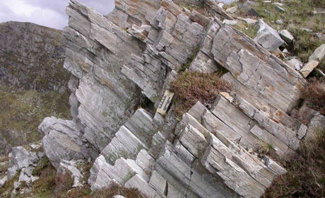
The impressive mylonites of the Cambrian quartzites at the Stack of Glencoul
The sea lochs of Glencoul and Glendhu are dramatic landscape features, carved by repeated glaciations. Their flanks provide some of the best 3D thrust geometries in the British Isles, with spectacular cross-sections into the Moine Thrust Belt.

The area is historically important for the discovery of thrust tectonics in the 1880s, here through the pioneering work of Charles Callaway. He recognized that a sheet of Lewisian gneiss, some 300m thick, had been carried up onto Cambrian strata – on a structure we now know as the Glencoul Thrust. The area was subsequently mapped by Clough in the later 1880s and it is his map upon which modern tectonic understanding is built.
By correlating Precambrian structures carried in the Glencoul Thrust Sheet with the stable “foreland” areas to the west, the displacement on the Glencoul Thrust can be estimated at 25-30 km.

Today, the views from around the village of Kylesku and the 1980s road bridge across the narrows of the sea loch are amongst the most gazed upon in Scottish geology. The Glencoul valley provides a complete section through the Moine Thrust Belt in northern Assynt. At the back of the valley lies the Stack of Glencoul – which contains spectacular and important outcrops of the Moine Thrust and its associated highly sheared rocks (termed mylonites).
Thanks to its deeply incised valleys, the Glencoul area is a really important location for teaching 3D thinking in students – a key skill for modern geoscientists as they interpret the Earth’s subsurface.
These locations lie in the heart of the NW Highlands Geopark.
Text: Professor Rob Butler